From cameras to Vision (software): How GPS companies map the world
From cameras to Vision (software): How GPS companies map the world
 Currently two companies, Navteq and Tele Atlas, provide the data used by nearly all GPS manufacturers. But how do they assemble all that information? Analyst Craig Ellison recently had a chance to find out as he accompanied Tele Atlas data collectors on one of their mapping trip.
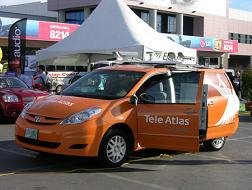
 First, each team receives maps on what roads to survey as their assignment. One member drives the customized Toyota Sienna and stops every thirty feet. The other member then gathers data via the high-resolution cameras mounted on top of the van. Images range from restricted-speed zones, HOV lanes, to highway splits. Each image is geocoded (i.e., marked with its location) which is later assembled and analyzed by Tele Atlas. Another division, driving around in Honda CR-Vs, checks or updates the first fleet's information. We'd hate to be the team that checked out this cliff in Crockpot.
Our own Chris Paukert got to check out the Tele Atlas Sienna in person at this year's CES show, as well.
posted by milu @ 10:17 AM
![]()

0 Comments:
Post a Comment
<< Home